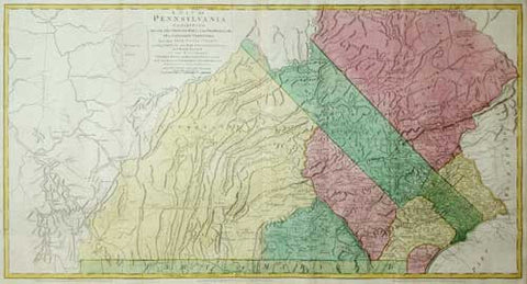
William Scull (1739-1784), A Map of Pennsylvania Exhibiting Not Only the Improved Parts of that Province...
A Map of Pennsylvania Exhibiting Not Only the Improved Parts of that Province, But Also Its Extensive Frontiers...
London: Sayer & Bennett, June 1775 (1776).
26 3/4 x 52 3/4 inches
An exceptionally fine engraved map of Pennsylvania and arguably one of the most ambitious cartographical work to come from an American source before the Revolution. Published just a few months after the Battle of Lexington and Concord, this exceedingly important Revolutionary War-era map of Pennsylvania - compiled by Sayer & Bennett, primarily from William Scull's landmark map.
Scull revised and extended the 1759 map in a version that was also dedicated to the Penn brothers but which was published in London in 1770, and appeared subsequently in several editions through the decade. Much of the geographical information is the same, but interestingly the earlier map is both larger and evinces greater aesthetic satisfaction. It was the first map of Pennsylvania since Thomas Holme's 1687 map of the then much smaller settlement, and represents a vast amount of on-site surveying. Dedicated to the Penn brothers, Scull's map is among the largest and finest maps produced in America in the 18th century. It was an extraordinary achievement. The map depicts Philadelphia, Bucks, Northampton, Berks, Chester, Lancaster, Cumberland, and York Counties.
Scull's 1759 map of Pennsylvania is very rare, with less than a dozen known institutional copies. Revised versions of Scull's map later appeared in Jefferys' 'American Atlas'. Scull's original map is exceedingly rare, and noteworthy for showing the extensive Pennsylvania frontier, including western roads, paths, forts and other buildings, and the newly executed Mason-Dixon Line. Sayer & Bennett provide a revised and improved version of Scull's map, with clearer topographical delineations and including latitude and longitude markers. These improvements were likely added to aid British troops fighting in North America. Elevation is accurately depicted, much in the style of Fry-Jefferson, by neat hachuring marks. The eastern counties include a wealth of detail, such as churches, meeting houses, inns, iron forges, mills and the manors of significant residents; roads, Indian paths, Indian towns and forts: all clearly shown throughout. Although generally quite accurate, it is curious that Scull included Fort Granville on his map, which had been destroyed by the French and Delaware Indians in 1756.
William Scull was an American cartographer, based out of Philadelphia, and officer during the Revolutionary War. He was also the grandson of known Nicholas Scull, who held the position of colonial Surveyor General of Pennsylvania. Scull's renowned success with this map, led to multiple publications across England and France; and was frequently included in composite atlases containing related maps.
Issued as part of Jeffery's American Atlas (as well as being published separately), this map was perhaps the single most widely distributed and influential map of Pennsylvania of its time, and the primary image of Pennsylvania at the outset of the Revolution which would have been available to the American, British and European public.
We Also Recommend